Many countries in Asia and the Pacific are exposed to flood risks from typhoons, flash floods, riverine flooding, storm surges and coastal flooding. Flood risk compromises sustainable economic growth and prosperity, which will be further impacted by rapid urbanization and climate change.
The Asian Development Bank (ADB) promotes and adopts an integrated and risk-based framework for flood management. Integrated flood risk management (IFRM) is a framework that promotes sustainable, long-term flood resilience by combining social, economic, financial, environmental, and institutional solutions, as well as those involving engineering, disaster preparedness, insurance, and emergency response.
The overarching concept is to manage the risk posed by floods to an acceptable and affordable level, rather than control the physical waters or fully protect communities against floods of all magnitudes.
Flood risk management plans or projects require an understanding of both the technical nature of the flood as well as the way in which it interacts with land, the communities that occupy it, and development plans. Sound analysis based on quantitative data helps in understanding the physical attributes of a flood, while interaction with stakeholders aids understanding of land use and affected communities’ exposure and vulnerability.
The objective of IFRM is to cost-effectively manage the risks posed by floods across landscapes, considering existing and future scenarios, and to improve flood resilience by:
- minimizing economic damages and loss of life, and limiting potential negative impacts to health, well-being, and economic development;
- maximizing sustainable economic benefits of land use; and
- improving or maintaining floodplain ecosystems dependent on flood inundation.
The approach has the advantages of being robust, flexible, and adaptable, as well as comprehensive. It encompasses wider benefits than could be provided by any single solution.
Flood risk management is rarely entirely about flooding. Often flood issues cannot be separated from broad economic and social development issues, as well as land and environmental management. Adopting a holistic, risk-based integrated approach allows for comprehensive solutions and linkages to other opportunities.
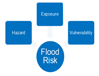
Flood risk is normally described as a function of three components: hazard, exposure, and vulnerability.
Source: Asian Development Bank. Strengthening Integrated Flood Risk Management: A Practical Guide to Integrated Flood Risk Management. Consultant’s report. Manila (TA 9634-REG).
- A flood hazard is a flood event that is potentially damaging and has three main characteristics: source, magnitude (depth, velocity, and duration that causes damage), and location or extent. The magnitude of the flood hazard is usually described using the term annual exceedance probability (AEP) or return period.
- Exposure refers to people, property, assets, systems, or other elements present in flood hazard areas that are thereby subject to potential loss and damage. Since a dominating factor is the density of population and infrastructure, exposure will increase with population growth and rural-to-urban migration. Furthermore, as the quality of life increases in developing countries, so does the relative value of assets exposed and their potential loss.
- Vulnerability refers to the characteristics and circumstances of a community, system or asset that make it susceptible to the damaging effects of a hazard. High vulnerability can create large losses from even moderate hazards. In poor and highly vulnerable areas, the frequent small- or medium-scale floods can have a significant cumulative effect.
Flood risk will be exacerbated by climate change. Sea-level rise by 2100 strongly depends on future emissions, predicted to reach about 0.40 m for very low emissions (global warming close to 1.5 °C), about 0.8 m for very high emissions (global warming above 4 °C), and 1 m more if ice-sheet instability processes associated with deep uncertainty are triggered. Due to relative sea-level rise, extreme sea-level events are projected to occur more frequently.
Climate change is also expected to significantly increase the intensity of extreme rainfall and droughts in some areas. Further, more frequent extreme typhoon and storm surge events are projected that will increase the likelihood and rate of coastal flooding and coastal erosion. The impact of climate change will depend on actions for managing and mitigating risk, and guiding socioeconomic dynamics.
Identifying risk with data and decision-making tools is necessary for risk-informed structural and non-structural measures and land use development. Risk-informed spatial planning is a key tool for managing exposure for fixed assets, such as houses, factories, and other infrastructure. Appropriate land use planning for new development should ensure separation between flood-prone areas and fixed assets. Structural measures help mitigate the impact of natural shocks on people, reduce disruptions, and improve living standards. Nature-based solutions can complement the protective function of structural measures, while also contributing to improved livelihoods. Even with effective risk reduction systems in place, there is a chance of experiencing flood impacts. Emergency response, relief and recovery plans are key for managing residual risks. Flood preparedness can be enhanced with flood forecasting and early warning systems, and, at the local level, improved knowledge can ensure better responses for flood-proofing or evacuation. Institutional strengthening should target coordination, communication, and decision-making systems. Social protection systems, disaster risk financing strategies, and insurance can also help manage residual risk.
ADB have been supporting the Asia and Pacific region address flood risks by project/program investments and technical assistance, by creating knowledge and by building the capacity of local governments and institutions managing flood risk. Click on the resources below to learn more.
Knowledge under TA-9634 Strengthening Integrated Flood Risk Management
Integrated Flood Risk Management: Practitioner’s Guide
A Practical Guide to Integrated Flood Risk Management
A Guide to Integrated Flood Risk Management Economics
Economic Analysis of Flood Forecasting and Early Warning Systems
Safeguard Considerations in ADB Flood Risk Management Projects
Managing Uncertainty in Integrated Flood Risk Management Using Dynamic Adaptive Pathways Planning
Gender and Social Inclusion Dimensions of Vulnerability
Selected ADB Nature-based Solutions Knowledge
Guidelines for Mainstreaming Natural River Management in Water Sector Investments
Nature-Based Solutions for Cities in Viet Nam: Water Sensitive Urban Design
RISE Reports: Water-Sensitive Informal Settlement Upgrading
Recent ADB IFRM Projects/Programs/Technical Assistance
PRC: Piloting Innovative Flash Flood Early Warning Systems in Selected River Basins (2018)
REG: Strengthening Integrated Flood Risk Management (2018)
REG: Building Coastal Resilience through Nature-Based and Integrated Solutions
REG: Applying Remote Sensing Technology in River Basin Management (2012)
CAM: GMS-CAM Flood and Drought Risk Management and Mitigation (2013)
BAN: Flood and Riverbank Erosion Risk Management Investment Program - Project 1 (2014)
BAN: Flood and Riverbank Erosion Risk Management Investment Program - Tranche 2 (2021)
THA: Community-Based Flood Risk Management and Disaster Response in the Chao Phraya Basin (2014)
INO: Flood Management in Selected River Basins Sector (2016)
IND: Assam Integrated Flood and Riverbank Erosion Management Investment Program - Tranche 2 (2018)
NEP: Priority River Basins Flood Risk Management (2020)
IND: Integrated Urban Flood Management for the Chennai-Kosasthalaiyar Basin (2021)
CAM: Flood Damage Emergency Reconstruction (2012)
PRC: Jiangxi Xinyu Kongmu River Watershed Flood Control and Environmental Improvement (2017)
CAM: Advance Actions for the Flood Damage Emergency Reconstruction Project (FDERP) (2012)
SOL: Transport Sector Flood Recovery (2014)
AFG: Northern Flood-Damaged Infrastructure Emergency Rehabilitation (2014)
PAK: Flood Emergency Reconstruction and Resilience Project (2015)
PAK: Post-flood National Highways Rehabilitation Project (2016)
PRC: Hunan Miluo River Disaster Risk Management and Comprehensive Environment Improvement (2021)
BAN: Coastal Towns Climate Resilience Project (2022)
VIE: Climate Adaptive Integrated Flood Risk Management Project (2022)
PRC: Chongqing Longxi River Basin Integrated Flood and Environmental Risk Management Project (2022)
Relevant ADB Publications
A Region at Risk: The Human Dimensions of Climate Change in Asia and the Pacific
Evidence from Measuring Community Flood Resilience in Asia (October 2019)
Reconnecting Solomon Islands After the Cyclone Ita Floods (December 2019)
Pakistan: Responding to Disaster with Partnership (November 2018)
In Pakistan, a Devastating Flood has Helped People Prepare for Climate Change (December 2015)
Other ADB Publications
Transforming urban–rural water linkages into high-quality investments. ADB’s Technical Paper
Innovative flash flood early warning system can save lives and property
Technology and Tradition Save Lives from Flash Flood Disasters in the People’s Republic of China
How the Growing Use of Geographic Information Systems Can Benefit Society
Flash Flood Forecasting and Early Warning Saves Lives and Combats Poverty
Here’s How Governments Can Reduce the Impacts of Asia’s Devastating Flash Floods
Strengthening a City's Water Resources and Flood Management Capacity. Case Study-Development Asia
The health of Asia’s rivers lies both in the cities and on the farms. ADB Blog
Exploring new ways to manage the devastation caused by floods. ADB Blog
Strengthening a City's Water Resources and Flood Management Capacity